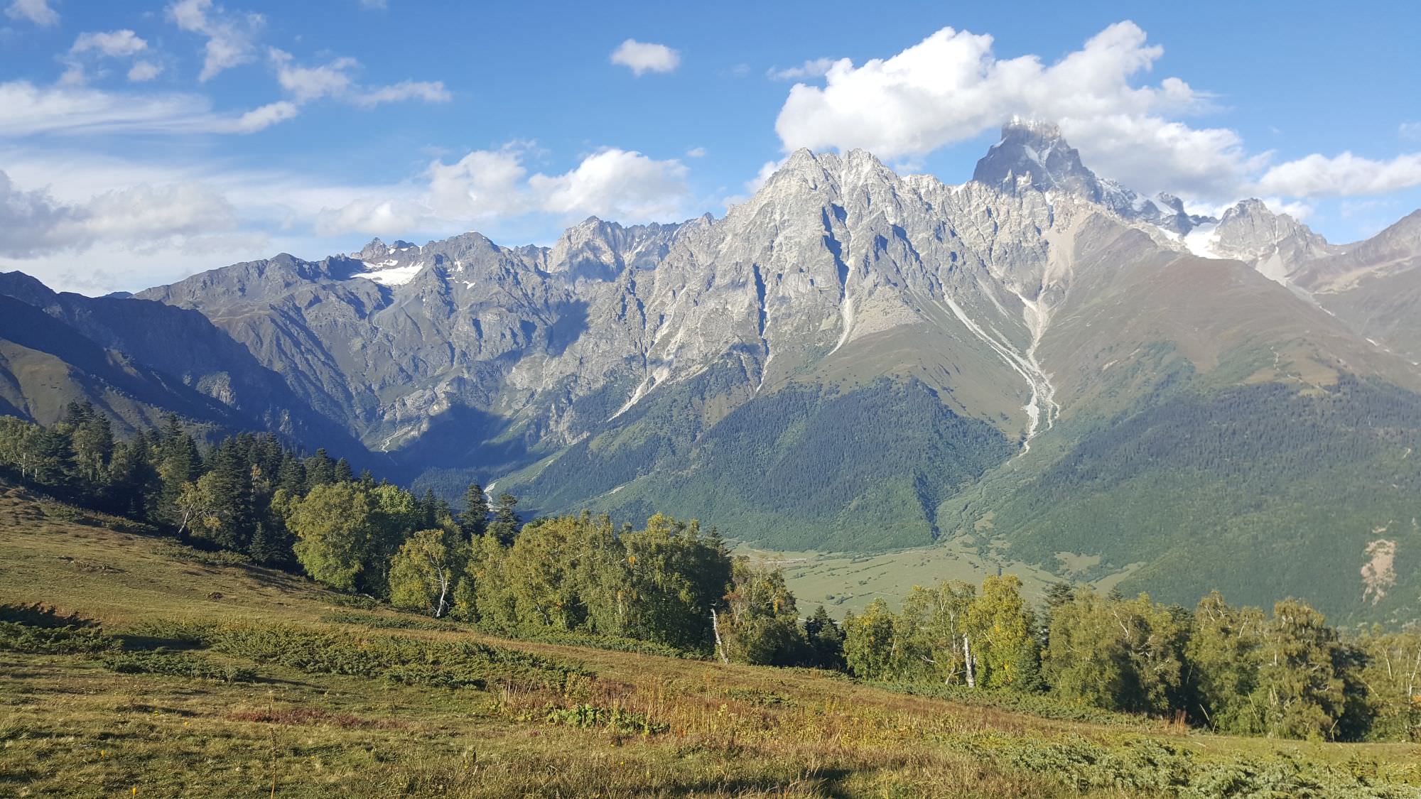
Mazeri is the last one in the line of settlements dotting Dolra valley, a side valley located a little west of Mestia. Getting here requires some effort - there is no marshrutka or public transport, so you must take a taxi, hitchhike or walk. So what makes it a popular hiking destination? Mainly the fact that it is sitting right beneath Mt. Ushba (4731m) - with some minor furniture rearrangement, its western horn might be the first thing you see once you open your eyes in the morning. And that is just the beginning - hiking trails around Mazeri spread in all directions.
Another thing I like about this place - despite many guesthouses, it managed to keep its rural charm. There is only one shop and a couple of restaurants so you won´t see many tourists there. They have nowhere to go in the evening. But that´s not a problem, people come here mainly for relaxation or hiking. And since it´s not that easy to get here, you should take your time and explore. This list could help you out with that a bit ;)


| Distance | 22,6 km |
| Trail type: | AB trip |
| Duration: | 9 hours |
| Total climb: | 1693m |
| Total descent: | 1464m |
Probably the best-known hike on the list. Leave early, because this one will take you the whole day - you shall cross 2950m high Guli pass and eventually end up at Mestia. Only hike on the list that rewards you with those famous vistas of the southern side of Mt. Ushba, with both "horns" visible.
Hikers usually schedule this hike for thir last day at Mazeri, since they probably have to get to Mestia anyway. If you would like to end up at Mazeri, you can hike only to Guli pass (or even Mt. Gul) and then return the same way you arrived.
Difficulty: Hard
When to go: 2nd half of June - early October

| Distance | 14,8 km |
| Trail type: | Roundtrip |
| Duration: | 5-6 hours |
| Total climb: | 522m |
| Total descent: | 522m |
The busiest hike on the list. It follows Dolra river valley, then crosses the river and climbs to a pretty impressive waterfall. Shdugra waterfall is fed directly by Ushba glacier and is so powerful that one has to wonder how there is still any ice left up there.
If you walk from the village, you might like a path on the western bank of the river, which is calmer and shaded. However, many tourists prefer to take a taxi to the Hiker's cafe situated almost halfway to the waterfall to cut 2-3 relatively "boring" hours from the walk. You may do the same or try your luck hitchhiking on the road east of the river.
Difficulty: Easy
When to go: April - November

| Distance | 21,2 km |
| Trail type: | AB trip |
| Duration: | 8 hours |
| Total climb: | 1123m |
| Total descent: | 1123m |
An extension to the Shdugra waterfall hike, which makes it look like a warm-up. It climbs another 500 altitude meters to the Ushba glacier, offering a different perspective of the mountain. On the way up, you shall overcome some steep terrain as well as a tricky creek.
Just keep in mind that you will cross a border guard post. Soldiers usually do not care about daytrippers, but one never knows - better bring your passport.
Difficulty: Hard
When to go: late June - early October

| Distance | 17,9 km |
| Trail type: | AB trip |
| Duration: | 6-7 hours |
| Total climb: | 1043m |
| Total descent: | 1207m |
Baki pass crossing is mainly popular among Svaneti through-hikers - most trek in the west-east direction. But since this post is about Mazeri, let's pretend that someone hikes in the opposite direction ;)
This hike climbs to the Meziri church at the southern edge of the mountain range, traverses north to the Baki pass (2416m), and descends to Etseri. If you do not want to end up at Etseri (you would have a hard time getting back), you can make this hike as a loop and from Baki pass drop back into Mazeri via a barely visible, mostly overgrown path through the meadows or just return the same way you arrived.
Difficulty: Moderate
When to go: mid May - late October

| Distance | 16 km |
| Trail type: | Roundtrip |
| Duration: | 10 hours |
| Total climb: | 1929m |
| Total descent: | 1929m |
An epic hike following the mountain path that was very popular decades ago, but fell into obscurity after the dissolution of the Soviet Union. It heads north, into the Kvish valley. It follows it almost to the foot of Dolra glacier and then makes a steep climb towards the Becho pass at the border. We didn't make it to the pass and not sure if it's advisable - there is a receding glacier in-between. Ended our hike at the 3100m viewpoint, 200 altitude meters below the pass (hence only "towards" in trail description and not "to").
Kvish valley belongs to the restricted border zone, to get here, you would need a proper permit (you can get it at border guards offices behind Mestia airport and in the Ushkhvanari village).
Difficulty: Hard
When to go: early July - late September

| Distance | 13.4 km |
| Trail type: | Roundtrip |
| Duration: | 7 hours |
| Total climb: | 1431m |
| Total descent: | 1431m |
Solid, little-known hike climbing from Mazeri onto the alpine meadows beneath Mt. Ushba. A rather long walk on the dirt road through the forest is not that interesting, but once you reach the treeline, magnificent views open up. Follow the road a bit further, past a small pond, to its highest point, where it turns down into Gul valley (and disappears 100m later). These pastures are known among Svans as Lemel.
From Lemel, one can return the same way but, if you still have some gas in tank left, you might climb a but further, towards Meshkhol.
Difficulty: Moderate
When to go: late May - late October

| Distance | 15.6 km |
| Trail type: | Roundtrip |
| Duration: | 9 hours |
| Total climb: | 1761m |
| Total descent: | 1761m |
An obvious extension to the Lemel hike. Once you emerge from the forest, you will see an imposing ridge connecting Ushba massif right in front of you. The top of the ridge is flat at its very end, there the walking terrain turns into a climbing one, is called Meshkhol ("black rocks"). To get here from Lemel, you shall need more than an hour, and a half of that time to get back. Still, the place is beautiful, with new views of Guli glacier. If it didn't take so long to get here, I could easily spend hours here, just resting against the rock and looking around.
Difficulty: Moderate
When to go: mid June - early October

| Distance | 16.2 km |
| Trail type: | Roundtrip |
| Duration: | 8 hours |
| Total climb: | 1480m |
| Total descent: | 1480m |
This route, while little-known among hikers, is quite popular among mountaineers since it forms an approach to a classic Gabriel Khergiani route climbing South Peak of Ushba. It follow the trail to the Guli pass, but then turns into the valley of Gulichala river and keep climbing. From the glacier, you will have panoramic views of the Svaneti range to the south, and close-up views of Ushba and neighboring Mt. Gulba.
Difficulty: Moderate
When to go: mid June - early October

| Distance | 28.2 km |
| Trail type: | Roundtrip |
| Duration: | 12+ hours |
| Total climb: | 2050m |
| Total descent: | 2050m |
Mt. Simzagar (3311m) might be of particular interest to peak baggers - it is probably the highest peak achievable from Mazeri in a (very long) day. It climbs west, to the Baki pass and then circumnavigates the ridge from the western side, gradually climbing until it reaches the summit. A long, complicated route, for which you should probably hire a local guide. But, it should go without saying that views from the top are spectacular.
Difficulty: Very Hard
When to go: July - September

| Distance | 14 km |
| Trail type: | Roundtrip |
| Duration: | 8 hours |
| Total climb: | 1834m |
| Total descent: | 1834m |
Another hike exploring the upper reaches of the Dolra valley. However, this one, shortly after the confluence of Dolra with Kvish, turns sharply right and starts "returning" the same way you arrived, only hundreds of meters higher. The trail eventually climbs to the Hirblash plateau at an altitude of 3050m, which also serves as a terrific campsite - from here, one can admire the twin peaks of Ushba as well as the Ushba glacier.
Reaching the plateau is more than enough for the da yhike. However, if you decide to spend a night here, on the next day, you can continue further to the Nak glacier and return to Mazeri. Just keep in mind that also for this hike, you will need a border zone permit.
Difficulty: Moderate
When to go: late June - September

| Distance | 24 km |
| Trail type: | Roundtrip |
| Duration: | 8 hours |
| Total climb: | 1763m |
| Total descent: | 1763m |
Another summit that can be done in a day, using Mazeri as a base. While it lies in the vicinity of Mt. Simzagar, Mt. Bak (3286m, or some maps marked as Mt. Tsirniari) is a bit lower and also much easier to reach.
That's mainly because there is nowhere to get lost - once you make it to the Baki pass (2416m), you simply follow the top of the ridge to the north until you reach the summit.
Difficulty: Hard
When to go: late June - September

| Distance | 9.2 km |
| Trail type: | AB trip |
| Duration: | 3 hours |
| Total climb: | 405m |
| Total descent: | 674m |
This trail offers the most direct connection between villages Svan Mazeri and Latali as well as some nice views of Mt. Ushba. It doesn´t work too well as a stand-alone hike but could be useful to people who need to leave Mazeri village, don´t want to pay for a taxi and have a few extra hours for a nice and pleasant walk.
The trail heads from Mazeri south to Ushkhvanari
Difficulty: Easy
When to go: late June - September